Posts

Showing posts from 2011

Accretionary Wedge #38: Back to School

In response of Anne Jefferson questions for Accretionary Wedge #38 : If you are a current or future student… what do you want to know about life and careers in the geosciences? Are there things you aren’t getting to learn or do in classes that you think are important? What sort of experiences do you want to get out of school and how do you think school can or should help you prepare for a career? My respond here focus on, the method of studying geology. It's helpful to study how particular branch of geoscience are developed, like how continental drift theory are become the most accepted theory, but it's not necessary to study how seismic investigation are developed thorough the time. Students need to know how to interpret a seismic section; not to know who developed that branch of science so the large introductions of any subject in collage is like wasting the time. How is this branch of science work? why it useful? and how can i use it? that what i think is  important in stud

Science Online London: FEAR of science blogging!

Image
How is the web changing science? Join Science Online London 2011 to find out. My brain tried to find out that with others on twitter the best brainstorming online tools on web. I tweet a lot of thoughts, and questions about science blogging and science policies during the live stream . And here is some of the problem that I'm interested in it. Personally i hate speaking on behalf of employers or organizations, I hate that fear of say something unprofessionally, specially when you wondering or blogging about your job or your career. You know that style of speaking/blogging "I'm awesome and my employer/organization is the best" we say that, because we don't want to loss our jobs.

جمع من الفوائد

- معظم البيانات وملفات الحاسوب التي خزنتها خارجياً علي أقراص، لم أرجع إليها إلا إذا كانت بيانات هامة أرجع إليها عند الضرورة فقط. مما جعلني أقلل من حدة الحفظ المستمر للبيانات. - يجب زراعة نبات له رائحة طيبة و يساعد علي طرد الحشرات حول أماكن التخلص من الفضلات في المعسكرات والمخيمات مثل النعناع أو الياسمين أو غيره مما لا أعرفة، ويفضل أن يكون مكان التخلص من الفضلات حفرة حتي يسهل ردمها فيما بعد و بعيداً عن إتجاه الرياح بالمعسكر. ويمكن إستخدام الفضلات كوقود لتوليد الكهرباء أو التدفئة إن أمكن. أسعد بتعليقاتكم علي هذه الفوائد و أسعد ب إضافتكم لفوائد أخري.

The White Desert, Accretionary Wedge #37

Image
Mushrooms Image via Wikipedia The White Desert is located at the northern region of the Farafra Oasis . I had visited it within field trip to western desert. The white desert has been classified by government of Egypt as a natural protected zone in 2002 and covers an area of 3010 square kilometers. It's far 570 km from Cairo. The White desert is a unique geological phenomenon; where wind and water erosion sculptured their way through the soft chalk forming incredible shapes "Mushrooms". Along the road Baharia - Farafra, the main geological observations as many isolated hills and hillocks consisting almost of massive bedded, snow white chalk of Maastrichtian Khoman Formation. There are many fascinating geomorphologic feature accompanied the carbonate rocks of the plateau surface such as cave deposits and onyx,

Science Blogging Q&A

Image
There was some questions in my mind when i start my blog, How to make a good blog? How to blog? What is the best style for science blogging? I got some good answer lately, I think it's useful enough to share it here with sci bloggers who want know the answer or have answers of the following questions. What is the best blogging service for scientists (Blogger, Wordpress, tumblr, or Posterous etc.)? Obbie King : The best blog for a scientist (or anyone, for that matter) is the one that that particular person finds most comfortable to work with and that most effectively communicates the content he/she is presenting. I would suggest "playing around" with some of the more popular platforms, look for ways to make it "look" the way you want, and decide which platform makes you feel more comfortable. You then may wish to get help from someone who's well-versed in your chosen service to set up the fine details and get you rolling.

Aquifers Properties: Specific Yield and Specific Retention

Image
Aquifers Properties: Specific Yield and Specific Retention In an aquifer with a water table (unconfined aquifer), the volume of water released from groundwater storage per unit surface area of aquifer per unit decline in the water table is known as the specific yield, S y . also known as the drainable porosity. Hydrologists divide water in storage in the ground into the part that will drain under the influence of gravity (called specific yield) and the part that is retained as a film on rock surfaces and in very small openings (called specific retention). The physical forces that control specific retention are the same forces involved in the thickness and moisture content of the capillary, fringe. fig.1

Aquifers Properties: Porosity (n)

Image
Aquifers Properties: Porosity (n) The porosity of a soil or rock is that fraction of a given volume of material that is occupied by void space, or interstices. Porosity, indicated by the symbol ( n ), is usually expressed as the ratio of the volume of voids. Most rocks naturally contain a certain percentage of voids that can be occupied by water. Fig. 1 Porosity (n)

Location of Lost Circulation Zone Dilemma

Image
Lost Circulation is one of the major drilling problem geologists and drilling engineer’s struggling it while drilling a well for both oil/gas and groundwater. If a very porous, cavernous or highly fractured zone is encountered while drilling; an excessive amount of drilling mud is lost to that zone during lost circulation. The zone is called a thief or lost circulation zone. In this case I’ll explain dilemma I faced while drilling groundwater well in North Sinai, Egypt we expecting the aquifer at 1200m. Within drilling community North Sinai distinguishing by repetitive Lost Circulation. I joking with my colleagues we need to invent (Lost Circulation Preventer) instead of (Plow out Preventer). That lead me to design Excell worksheet to make cement job calculation easy work , because I think every repetitive work should has a system to make it done. The following table is the important data about lost circulation zones: Depth(m) Lithology/comment From to 372 404 Dolomite,

2012: Ice Age declares war on the theory!

http://youtu.be/zxbiNWSNPTk After watching this movie, my personal opinion about 2012 Ice Age is the most stupid science fiction movie I have ever seen; everything is not realistic. Even the main idea (declares war on the glaciers) is not realistic. I think this movie show the ‘next ice age’ as a theory in a bad way to promote global warming theory. #BadGeologyMovie

Favorite Geology Word: Isopach (Accretionary Wedge #35)

Image
This my first post to  Accretionary Wedge Geoscience Blog Carnival . The current topic for AW#35 is “ What's Your Favorite Geology Word? ” hosted by Evelyn Mervine . My Favorite Geology Word Is - Isopach Definition: A contour that connects points of equal thickness. Commonly, the isopachs, or contours that make up an isopach map, display the stratigraphic thickness of a rock unit as opposed to the true vertical thickness. Isopachs are true stratigraphic thicknesses; i.e., perpendicular to bedding surfaces.( Source ) Pronunciation:  'ī-sə-ˌpak Date:  approximately 1918 Structure map includes an isopach of the reservoir with contours shown in red dashes. Venezuela Well Evaluation Conference, 1997, page 2-26 Source: http://www.glossary.oilfield.slb.com/ Isopach is a Map of the thickness variation of a stratigraphic unit; used in geological exploration for oil and for underground structural analysis.  I always love to draw it due to it's importance

Scientific Quotes

"Whereas non-scientific (and potentially dangerous) thinking starts with a premise and then looks for things that support it, scientific thinking constantly tries to disprove itself. That alone makes all the difference in the world." Derren Brown

LinkedIn Recommendation

Unfortunately you can't use your LinkedIn recommendation to apply to any Scholarships and some companies doesn't care about your online recommendation. If you want to apply to 3 Scholarships, your recommenders will hate you because of your recommendation requests. I'm thinking about establish online recommendation system confidential and validated by most of universities and multinational companies in the world. To help job seekers and students to use the power of the web to get hire or win a scholarship. I will be Entrepreneur :)

Sannur Caves in BeniSuef

Image
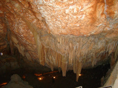
stalactites Sannur Cave is characterized by the presence of geological formations known as Stalactites and Stalagmites in a perfect beautiful formed over millions of years, about 60 million years ago dates back to the Era of Middle Eocene. Leakage of aqueous solutions of calcium carbonate saturated through the roof of the cave and then evaporated, leaving the mineral salts that accumulated in the form of deposits of stalactites and stalgmites. Sannur cave extends a distance of about 700 m, breadth about 15 m and depth is about 15 m. It’s Located in Beni Suef province, Egypt. about 70 kilometres southeast of the city. The cave is important to the scarcity of such natural formations “Egyptian Alabaster” as it is of great importance for researchers, Geologists, and Caving fans. Location: كهف وادي سنور في بني سويف من أجمل الكهوف التي رأيتها في حياتي. ما تراه في الصور هي أحجار جيرية نتجت عن عمليات التبخر من مياه الينابيع الحارة داخل الكهف، أو من عمليات ترسيب بطئ من قطرات ال

Geology Quote

"I have a Bachelor of Science degree in geology from the City College of New York, and my great contribution to the field of geology is that I never entered it upon graduation." - Colin Powell

Cleaning the environment from the dirty oil

I watched amazing documentary film about Mega structures: Black gold fields on National Geographic Channel Abu Dhabi . Extraction of the petroleum deposit in Canada required Mega structures. Oil sands will be the future of the oil industry. Shell challenge Syncrude in better production, but Shell system for extraction oil from sands uses large amount of water, producing waste water. Officially they use this water for planting wood, but the trees required long time to grow and use this large amount of the waste water. what make me blog this post is Shell environmental engineer opinion: look at the bright side! we are cleaning the sand from the oil, we cleaning the environment from the dirty oil!! هياكل عملاقة: حقل الذهب الأسود

Egypt Earthquake

A strong earthquake has hit the coast of the Greek island of Crete- aftershocks felt in Egypt .1 hour ago i felt earthquake at my home in Ismailia, Egypt but nothing damage here thanks god. Nile News report it's 5.9M. Actually this the third  earthquake i felt in my live. I still remember the first earthquake i felt in 1992 . thanks god!

It’s All Geek to Me! WordPress

Image
It's name of a session in ScienceOnline2011 the fifth annual international meeting on Science and the   Web. On January 13-15th, 2011. I delayed to blog about it, because I'm struggling lost circulation at depth 437m in limestone i fixed it previously but it revenge from us, we are now at 891m depth. It but me in bad mood to blog about what I'm thinking to improve my blog. During the online streaming of this session a pulse in my mind push me to ask; What is the best blogging service for scientist Blogger, Wordpress, etc.? you will see my question and the answer at time 48:12 Sorry geeks, it was confusing to me. Thank you for your answers. Here is the vid about that session "It’s All Geek to Me" enjoy watching [vimeo 21043520 w=400 h=225] Sorry This video does not exist. I found the best discussions for my question here on Discussing WordPress for Scientists . Also  here is my Q? on LinkedIn Answers http://linkd.in/gN3yPS. I blog to help my ca

Mapping water table contour map on Grapher

Image
This post about when student like me try to digitizing paper map:

Colors on Geology: Culture Problem

Colors on Geologic Time Scale or on Geologic Maps form a problem to all geologists around the world, there are many standards  in color. I'll not speak about the history of colors or the culture behind the difference in colors, Geologic maps rely on color to symbolize the different ages of rocks. same area can be mapped in different colors, and you can use one or two reference to geologic time scale. USGS have standards and BGS have another standards, it's not the problem of 'Colors' and 'Colours' . When biologists made one DNA standards, they work on  the Human Genome Project to mapping the Human genome , the complete code of the human genome is one of the best science achievements. All Geologists need one standard for the geological time scale, or for Geologic Maps whatever it's source (origin) or it's culture. one standard is important for many scientific reasons.

Thought About Global Warming

Image
What if Global Warming not resulting by excess of Co2 level? What if the sun become more energize? I think global

Why science blogging?

Image
I have some personal reasons to blog about Geoscience and my career and I want to share my reasons with scientists and science student to encourage them to start blogging about science. Why I'm blogging?

North Sinai Cement Job Calculation

I worked for an Employer in North Sinai, Egypt as a Mud logger and well site geologist. North Sinai is distinguished by loss of circulation because of the large calcareous section (fractured limestone and

YES Network Africa Symposium 2011 2nd day

Image
This is my blog for the 2nd day of online YES Network Africa Symposium 2011 12 January 2011, i will continue with the same way i blogged the 1st day . i hope you like my blogging style. Actually i missed the starting, but what happened chronologically was: - Cecilia Mukosi - South Africa: Geo-hazards in the Vhembe Districts: Erosion, Landslides, and Earthquakes. Council of Geoscience S. Africa advises communities where to put cemeteries so that they are not put where geohazards occur. Need to conduct proper assesments in order to mitigate impacts from sinkholes in Pretoria - M. L. Diko, S. Africa - Community Engagement in Geohazard Management along the Cameroon Volcanic Line. Talk: Must encourage participatory approach between formal & informal education sectors for effective geohazard mitigation - Hassan Mdala talking about the social implications of the 2009 Karonga Earthquake in Malawi. 2009 Karonga earthquake was the largest and most destructive earthquake in the his

YES Network Africa Symposium 2011

Image
The YES Network is an international association of early-career geoscientists who are primarily under the age of 35 years and are from universities, geoscience organizations and companies from across the world. About the YES Africa Symposium I blog this event according to my opinions of the session i had participated in it online via Go To Meeting , i used twitter update to blog about this event, i arranged it chronologically. I hope this be useful. Twitter Hashtags for the event was #YESAfrica2011 Starting the event 1st day 8:30 Am Amel Barich from YES-Morocco talking about her PhD research

Geological Interpretation of Reflection Seismic Data

Image
Geological Interpretation of Reflection Seismic Data This my graduation research title "thesis" in partial fulfilment of requirements for B.Sc in Geology. The aim of this research is to help geophysicists and geologists new to the technique to interpret data while avoiding common pitfalls. The research providing simple guide for geologists to interpret seismic data in geological frame without mathematical or physical concept that applied in seismic interpretation. The geology department members accepted this research.