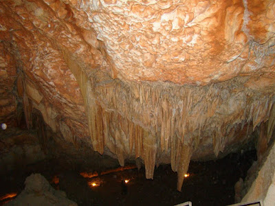
stalactites Sannur Cave is characterized by the presence of geological formations known as Stalactites and Stalagmites in a perfect beautiful formed over millions of years, about 60 million years ago dates back to the Era of Middle Eocene. Leakage of aqueous solutions of calcium carbonate saturated through the roof of the cave and then evaporated, leaving the mineral salts that accumulated in the form of deposits of stalactites and stalgmites. Sannur cave extends a distance of about 700 m, breadth about 15 m and depth is about 15 m. It’s Located in Beni Suef province, Egypt. about 70 kilometres southeast of the city. The cave is important to the scarcity of such natural formations “Egyptian Alabaster” as it is of great importance for researchers, Geologists, and Caving fans. Location: كهف وادي سنور في بني سويف من أجمل الكهوف التي رأيتها في حياتي. ما تراه في الصور هي أحجار جيرية نتجت عن عمليات التبخر من مياه الينابيع الحارة داخل الكهف، أو من عمليات ترسيب بطئ من قطرات ال...
تخصص الهندسة الجيولوجية - Geological Engineering نبذة عن تخصص الهندسة الجيولوجيَّة المقدمة عند الحديث عن علاقة الإنسان بالأرض وكيف تمكّن من تسخيرها لتطوير الحضارة البشريّة، تبرز الهندسة الجيولوجية باعتبارها البطل الصامت في هذه القصّة، حيث تعمل على استخدام قوى الطبيعة لتكوين عالم أكثر أمانًا. وبينما ننظر إلى هذا الكم الهائل من التحديَّات البيئيَّة، لا يُمكن المبالغة في أهمية هذا التخصص. خلف كواليس ناطحات السحاب الشاهقة ومشاريع البنية التحتية المترامية الأطراف ومواقع استخراج البترول والغاز الطبيعي، تمزج هذه المهنة بين الفهم القوي لطبيعة الأرض من ناحية ودقَّة الهندسة البشريَّة من ناحيةٍ أخرى. في هذا المقال، نُغطي كل ما تحتاج إلى معرفته عن هذا التخصص الهندسي العلمي الغني، ونعطيك رؤية شاملة عن التجربة التي ستمر بها إذا قررت دراسة هذا المجال وبدء حياتك المهنيّة فيه. نبذة عن تخصص الهندسة الجيولوجيَّة تُركِّز الهندسة الجيولوجيَّة في جوهرها على فهم طبيعة الأرض والمواد التي تتكوَّن منها وكيفية تصرف هذه المواد في ظل ظروف مختلفة. ومن خلال تسخير هذه المعرفة، يقوم الم...
The Biggest Mistakes Made by Geotechnical Drilling Companies in Saudi Arabia The recession in Saudi Arabia affecting all type of business. Oil price dropped and the country entered the Yemen war. Small geotechnical drilling companies made some mistakes to survive the current recession. Some of small companies did not survive and they closed/sold their business. below are the biggest mistakes: