Posts

Aquifers Properties: Porosity (n)

Image
Aquifers Properties: Porosity (n) The porosity of a soil or rock is that fraction of a given volume of material that is occupied by void space, or interstices. Porosity, indicated by the symbol ( n ), is usually expressed as the ratio of the volume of voids. Most rocks naturally contain a certain percentage of voids that can be occupied by water. Fig. 1 Porosity (n)

Location of Lost Circulation Zone Dilemma

Image
Lost Circulation is one of the major drilling problem geologists and drilling engineer’s struggling it while drilling a well for both oil/gas and groundwater. If a very porous, cavernous or highly fractured zone is encountered while drilling; an excessive amount of drilling mud is lost to that zone during lost circulation. The zone is called a thief or lost circulation zone. In this case I’ll explain dilemma I faced while drilling groundwater well in North Sinai, Egypt we expecting the aquifer at 1200m. Within drilling community North Sinai distinguishing by repetitive Lost Circulation. I joking with my colleagues we need to invent (Lost Circulation Preventer) instead of (Plow out Preventer). That lead me to design Excell worksheet to make cement job calculation easy work , because I think every repetitive work should has a system to make it done. The following table is the important data about lost circulation zones: Depth(m) Lithology/comment From to 372 404 Dolomite, ...

2012: Ice Age declares war on the theory!

http://youtu.be/zxbiNWSNPTk After watching this movie, my personal opinion about 2012 Ice Age is the most stupid science fiction movie I have ever seen; everything is not realistic. Even the main idea (declares war on the glaciers) is not realistic. I think this movie show the ‘next ice age’ as a theory in a bad way to promote global warming theory. #BadGeologyMovie

Favorite Geology Word: Isopach (Accretionary Wedge #35)

Image
This my first post to  Accretionary Wedge Geoscience Blog Carnival . The current topic for AW#35 is “ What's Your Favorite Geology Word? ” hosted by Evelyn Mervine . My Favorite Geology Word Is - Isopach Definition: A contour that connects points of equal thickness. Commonly, the isopachs, or contours that make up an isopach map, display the stratigraphic thickness of a rock unit as opposed to the true vertical thickness. Isopachs are true stratigraphic thicknesses; i.e., perpendicular to bedding surfaces.( Source ) Pronunciation:  'ī-sə-ˌpak Date:  approximately 1918 Structure map includes an isopach of the reservoir with contours shown in red dashes. Venezuela Well Evaluation Conference, 1997, page 2-26 Source: http://www.glossary.oilfield.slb.com/ Isopach is a Map of the thickness variation of a stratigraphic unit; used in geological exploration for oil and for underground structural analysis.  I always love to draw it due to it's...

Scientific Quotes

"Whereas non-scientific (and potentially dangerous) thinking starts with a premise and then looks for things that support it, scientific thinking constantly tries to disprove itself. That alone makes all the difference in the world." Derren Brown

LinkedIn Recommendation

Unfortunately you can't use your LinkedIn recommendation to apply to any Scholarships and some companies doesn't care about your online recommendation. If you want to apply to 3 Scholarships, your recommenders will hate you because of your recommendation requests. I'm thinking about establish online recommendation system confidential and validated by most of universities and multinational companies in the world. To help job seekers and students to use the power of the web to get hire or win a scholarship. I will be Entrepreneur :)

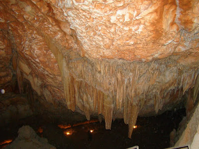
Sannur Caves in BeniSuef

Image
stalactites Sannur Cave is characterized by the presence of geological formations known as Stalactites and Stalagmites in a perfect beautiful formed over millions of years, about 60 million years ago dates back to the Era of Middle Eocene. Leakage of aqueous solutions of calcium carbonate saturated through the roof of the cave and then evaporated, leaving the mineral salts that accumulated in the form of deposits of stalactites and stalgmites. Sannur cave extends a distance of about 700 m, breadth about 15 m and depth is about 15 m. It’s Located in Beni Suef province, Egypt. about 70 kilometres southeast of the city. The cave is important to the scarcity of such natural formations “Egyptian Alabaster” as it is of great importance for researchers, Geologists, and Caving fans. Location: كهف وادي سنور في بني سويف من أجمل الكهوف التي رأيتها في حياتي. ما تراه في الصور هي أحجار جيرية نتجت عن عمليات التبخر من مياه الينابيع الحارة داخل الكهف، أو من عمليات ترسيب بطئ من قطرات ال...

Geology Quote

"I have a Bachelor of Science degree in geology from the City College of New York, and my great contribution to the field of geology is that I never entered it upon graduation." - Colin Powell