Posts

Showing posts with the label Feature

The Biggest Mistakes Made by Geotechnical Drilling Companies

Image
The Biggest Mistakes Made by Geotechnical Drilling Companies in Saudi Arabia The recession in Saudi Arabia affecting all type of business. Oil price dropped and the country entered the Yemen war. Small geotechnical drilling companies made some mistakes to survive the current recession. Some of small companies did not  survive  and they closed/sold their business. below are the biggest mistakes:

Geologic sample photo 2

Image
Here again we are drilling in Al-Namas , Saudi Arabia for geotechnical purpose and I am musing on samples for geologic purpose. Namas is a small town on the Arabian Shield . I still do not figure out the best catchy title for this blog series,

Programming language in geology/geophysics

Image
Programming language is an artificial language that is used to write programs in order to control the behavior of a computer.

Aquifers Properties: Specific Yield and Specific Retention

Image
Aquifers Properties: Specific Yield and Specific Retention In an aquifer with a water table (unconfined aquifer), the volume of water released from groundwater storage per unit surface area of aquifer per unit decline in the water table is known as the specific yield, S y . also known as the drainable porosity. Hydrologists divide water in storage in the ground into the part that will drain under the influence of gravity (called specific yield) and the part that is retained as a film on rock surfaces and in very small openings (called specific retention). The physical forces that control specific retention are the same forces involved in the thickness and moisture content of the capillary, fringe. fig.1

Favorite Geology Word: Isopach (Accretionary Wedge #35)

Image
This my first post to  Accretionary Wedge Geoscience Blog Carnival . The current topic for AW#35 is “ What's Your Favorite Geology Word? ” hosted by Evelyn Mervine . My Favorite Geology Word Is - Isopach Definition: A contour that connects points of equal thickness. Commonly, the isopachs, or contours that make up an isopach map, display the stratigraphic thickness of a rock unit as opposed to the true vertical thickness. Isopachs are true stratigraphic thicknesses; i.e., perpendicular to bedding surfaces.( Source ) Pronunciation:  'ī-sə-ˌpak Date:  approximately 1918 Structure map includes an isopach of the reservoir with contours shown in red dashes. Venezuela Well Evaluation Conference, 1997, page 2-26 Source: http://www.glossary.oilfield.slb.com/ Isopach is a Map of the thickness variation of a stratigraphic unit; used in geological exploration for oil and for underground structural analysis.  I always love to draw it due to it's...

Sannur Caves in BeniSuef

Image
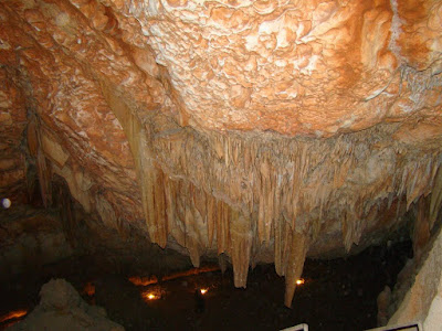
stalactites Sannur Cave is characterized by the presence of geological formations known as Stalactites and Stalagmites in a perfect beautiful formed over millions of years, about 60 million years ago dates back to the Era of Middle Eocene. Leakage of aqueous solutions of calcium carbonate saturated through the roof of the cave and then evaporated, leaving the mineral salts that accumulated in the form of deposits of stalactites and stalgmites. Sannur cave extends a distance of about 700 m, breadth about 15 m and depth is about 15 m. It’s Located in Beni Suef province, Egypt. about 70 kilometres southeast of the city. The cave is important to the scarcity of such natural formations “Egyptian Alabaster” as it is of great importance for researchers, Geologists, and Caving fans. Location: كهف وادي سنور في بني سويف من أجمل الكهوف التي رأيتها في حياتي. ما تراه في الصور هي أحجار جيرية نتجت عن عمليات التبخر من مياه الينابيع الحارة داخل الكهف، أو من عمليات ترسيب بطئ من قطرات ال...

Geological Interpretation of Reflection Seismic Data

Image
Geological Interpretation of Reflection Seismic Data This my graduation research title "thesis" in partial fulfilment of requirements for B.Sc in Geology. The aim of this research is to help geophysicists and geologists new to the technique to interpret data while avoiding common pitfalls. The research providing simple guide for geologists to interpret seismic data in geological frame without mathematical or physical concept that applied in seismic interpretation. The geology department members accepted this research.